

Portsmouth's Mt. Hope Park plan gets first public workshop
Abutters concerned about parking, project’s scope


PORTSMOUTH — Residents living near the proposed Mt. Hope Park in the north end of town raised concerns over parking, trash, the property’s stability and the project’s overall scope during the first public workshop Wednesday on the waterfront park’s development.
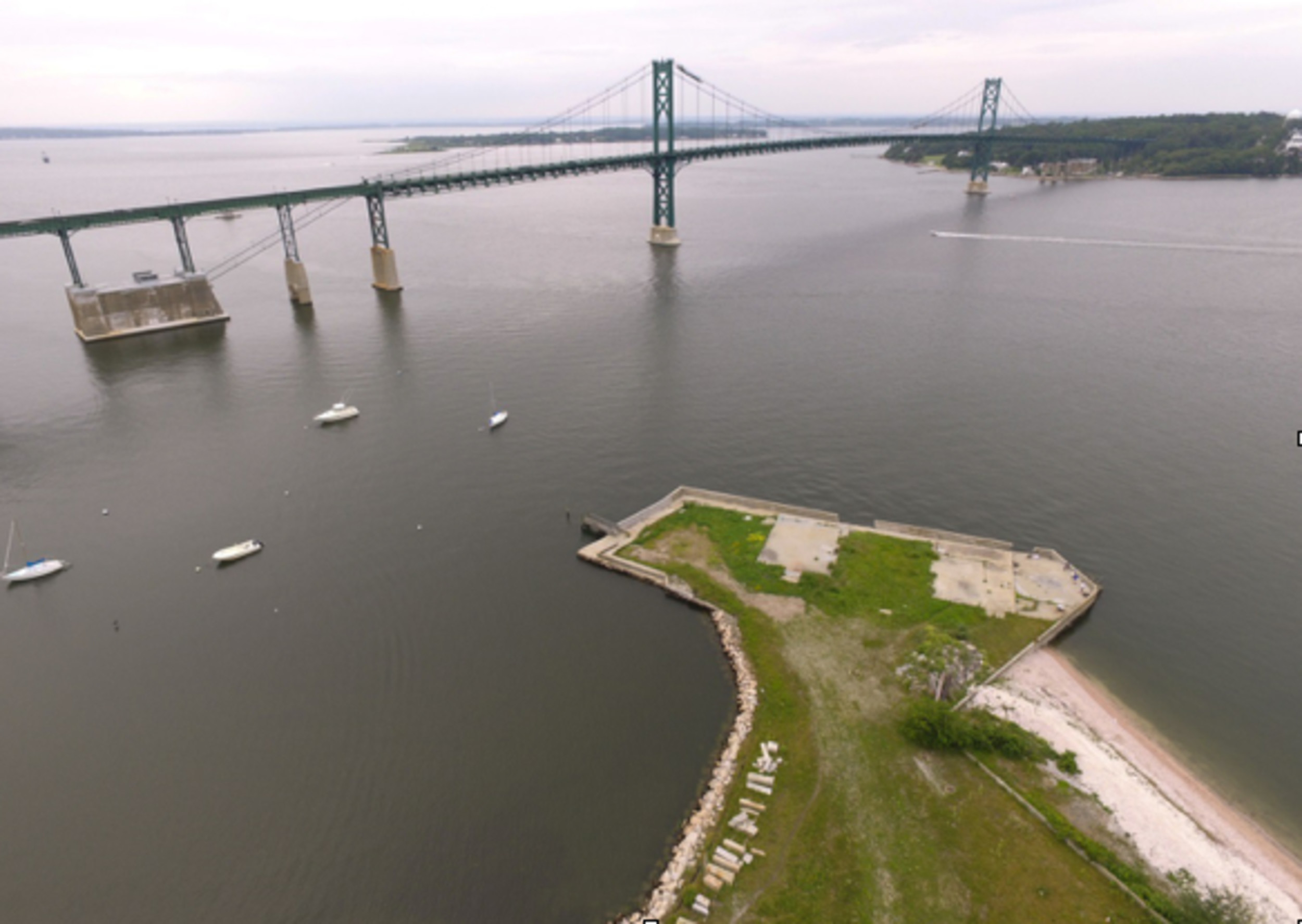
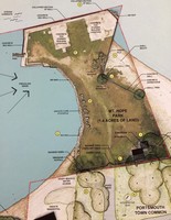
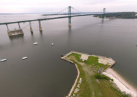
In January 2016, the Town of Portsmouth and the Aquidneck Land Trust (ALT) purchased about 5 acres of property — including about 1.5 acres of dry land jutting out into Mt. Hope Bay — for $900,000. Of that amount, $600,000 came from town funds allocated in the previous budget for bonding. The remaining $300,000 came from ALT.
The property, at the intersection of Bristol Ferry Road and Bayview Avenue, features scenic views of the Mt. Hope Bridge and surrounding water. ALT and the town plan to develop it as a new, permanently conserved park land.
Wednesday’s meeting was facilitated by a team from Horsley Witten Group, Inc., the consulting firm that conducted a site analysis of the property for the town and ALT. Feedback gathered from the 40 or so interested residents who attended will be used to develop a preliminary design for the land, according to Craig Pereira of Horsley Witten, the project manager.
After that, a preliminary design will be prepared and reviewed by residents at a second workshop that should take place within two months, Mr. Pereira said. The last phase involves developing a master plan, including a cost analysis.
(The van Beuren Charitable Foundation is funding the master planning process, pointed out Charles Allott, ALT’s executive director.)
“These are not concrete recommendations tonight; these are preliminary ideas,” said Mr. Pereira, who urged people to visit www.mthopepark.com for updates and more information. (A survey can also be taken here.)
Town Planner Gary Crosby said the workshops are being held in the interest of transparency and that he hopes the stakeholders will “basically act as watchdogs on what we’re doing.”
Mr. Allott said ALT has been involved with the preservation of farm properties and other land as open space, but this project is unique.
“We’ve never worked on a small park property in the more densely populated northern part of Portsmouth. It’s a spectacular piece of property,” said Mr. Allott.
ALT has a conservation easement on the land, which will be dedicated for use as a public park, Mr. Allott said. There are no big plans other than to clean it up, repair an old seawall and dock, plop down a few benches and perhaps install a gazebo, officials said.
The property, which was originally used as a ferry landing before it became the location for a restaurant destroyed by fire in 1985, includes a pump house and garage, an underground bunker filled with shells and multiple piles of rubble. A chain link fence now surrounds the property in the interest of safety.
Abutters’ concerns
Mr. Pereira, who said certified letters were sent to residents living within 200 feet of the property, acknowledged that abutters have expressed concerns over traffic, noise and other issues.
That became evident during a short Q&A portion of the meeting as well as a 50-minute session in which residents broke out into three groups.
The overriding concern was parking, with some residents saying they’re worried the area will be inundated with cars in the summer. The easement allows for only six parking spaces on the property, but several residents said they typically see more than a dozen vehicles parked on nearby streets during the summer.
Mr. Pereira responded his team will need to work with the town on police enforcement.
In response to one resident’s suggestion that the park be limited to Portsmouth residents, Town Council President Keith Hamilton said that’s not possible.
“It’s a public park,” said Mr. Hamilton, pointing out that town-owned Sandy Point Beach is also open to non-residents, although they must pay a parking fee.
Mr. Pereira said the abutting Bristol Ferry Town Common nearby will not be used for parking, which was another concern of abutters.
Others commented on the stability of the property, noting that it’s only eight feet above sea level at its highest point. One woman said she witnessed the 1954 hurricane and saw the water “go almost to the second floor of the existing building there. That’s your whole park.” Another resident said the restaurant “looked like a houseboat” during a hurricane in the ’70s.
Matt Schultz, senior coastal engineer with Woods Hole Group, which is part of the consulting team, acknowledged that any improvements will need to be designed with storms and sea level rise in mind.
“Most of the site would be inundated in a 10-year storm event,” said Mr. Schultz.
Another idea he mentioned, to install a wave attenuator (a “floating concrete dock”) to knock down wave energy and to offer an additional access point to the water, was greeted warmly by some residents.
No bathrooms, please
Residents also said they wanted no bathrooms or port-o-johns on the property, but they did favor trash receptacles to keep things clean. They also hope “the integrity” of the town commons is protected and that shoreline access, including for kayaks and canoes, is improved.
In addition, they voiced their wish to keep the land use passive in nature, although one breakout group recommended a small bandstand or gazebo to take advantage of the waterfront views.
Residents also heard a brief presentation of the history of the property from Doug Smith, chairman of the Bristol Ferry Town Common Committee, who noted that the site was used as a ferry landing as far back as 1680.
Keywords
Mt. Hope Park, Portsmouth Town Council, Aquidneck Land Trust, Bristol Ferry


